


Panama earthquakes remain an important topic for residents, travelers, and people following seismic activity in Central America. On October 9, 2026, a powerful earthquake struck near Pitaloza Arriba in Herrera Province, Panama. The United States Geological Survey (USGS) reported a magnitude of 7.7 and a depth of approximately 12.6 kilometers. The event was followed by additional seismic activity, raising concerns about aftershocks, building damage, transportation, and public safety.
This guide covers the reported October 2026 Panama earthquake, its magnitude and epicenter, reported damage, and potential effects on important infrastructure. You will also learn why Panama experiences earthquakes, how to check the latest USGS earthquake reports, and what residents and visitors can do to stay safe. For developing information about injuries, aftershocks, and infrastructure, consult official sources because initial reports and assessments may change.
Latest Panama Earthquakes on October 9, 2026
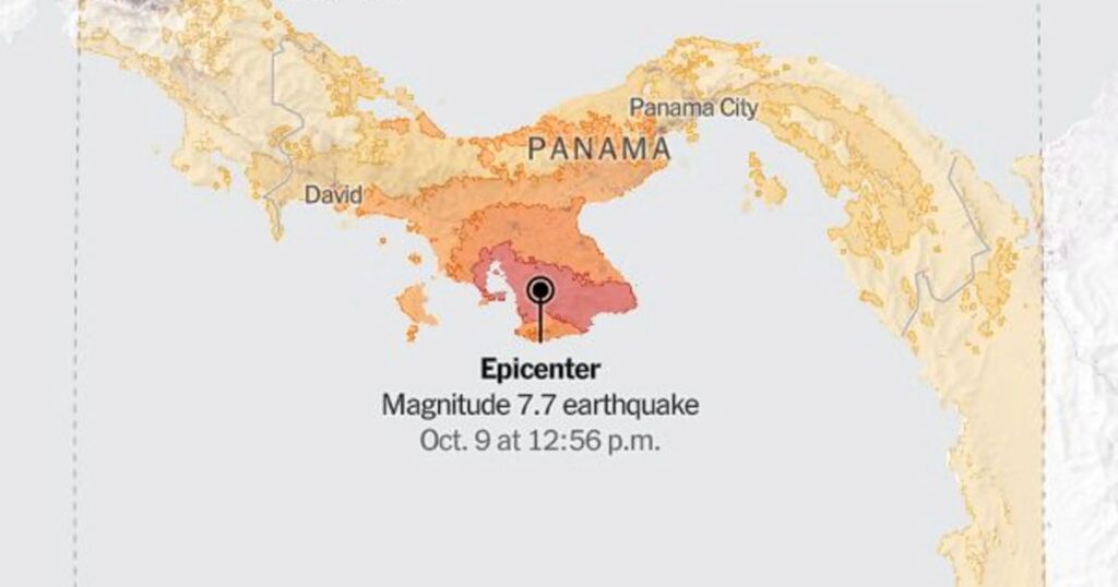
On October 9, 2026, a magnitude 7.7 earthquake struck near Pitaloza Arriba in Herrera Province, Panama, at 17:56 UTC, according to the United States Geological Survey (USGS). The earthquake occurred at a depth of approximately 12.6 kilometers. Its powerful shaking was felt across a wide area, including Panama City, where residents and office workers evacuated buildings as a precaution.
A second major earthquake, measuring magnitude 6.6, struck later that day near Río Grande, Panama. The two earthquakes were followed by numerous aftershocks across the affected region. Initial reports documented more than 45 aftershocks, while subsequent monitoring recorded substantially more seismic events. The total depends on the reporting period and monitoring agency, so readers should consult the latest earthquake catalog for current figures.
The earthquakes caused damage to buildings and other infrastructure in several provinces, prompting inspections and emergency response efforts. Authorities also monitored conditions affecting residents, transportation, and essential services. Because aftershocks can cause further damage to structures weakened by an earlier earthquake, people in affected areas should follow official safety instructions and avoid entering damaged buildings until they have been declared safe.
For the latest recorded earthquakes, magnitudes, depths, and locations, visit the USGS Latest Earthquakes map. Official records may be revised as scientists analyze additional seismic data.
Panama Earthquake Magnitude and Key Facts
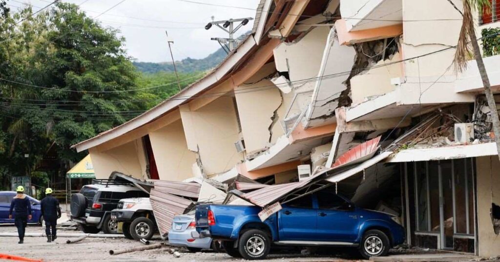
The October 9, 2026, Panama earthquake drew international attention because of its reported magnitude and the damage and disruption described in early reports. The United States Geological Survey (USGS) provides scientific information about earthquake magnitude, depth, and epicenter, while local authorities and news organizations report the effects on communities and infrastructure.
The following table summarizes the main details reported about the earthquake. Because earthquake measurements and damage assessments can be revised, consult the linked official sources before publishing updated figures.
| Earthquake detail | Reported information |
|---|---|
| Main earthquake date | October 9, 2026 |
| Reported magnitude | 7.7 |
| Epicenter | Near Pitaloza Arriba, Panama |
| Province | Herrera Province |
| Reported depth | 12.6 kilometers |
| Second major earthquake | Magnitude 6.6, reported near Río Grande |
| Aftershocks | Numerous subsequent seismic events; check the live USGS catalog for current counts |
| Reported impact areas | Parts of Herrera, Los Santos, Veraguas, and nearby areas |
| Tsunami warning | An initial warning was reported; check official records for its status and timing |
| Panama Canal | Initial reports indicated normal operations during inspections |
| Tocumen International Airport | Temporary suspension and subsequent resumption of operations were reported |
Earthquake magnitudes may be revised as seismologists analyze additional recordings. Such revisions are a normal part of earthquake monitoring and do not necessarily mean that a new earthquake has occurred. Similarly, aftershock totals change as more events are detected and cataloged. For the latest scientific measurements, consult the USGS earthquake catalog and compare them with official announcements from Panama’s emergency authorities. 7.6 and then 7.7. Such revisions are normal because scientists use additional seismic data to improve their initial estimates. The latest event page should be checked for the most current official measurement.
Read More: KJV Bible Guide to the King James Version and Its History
Where Did the Panama Earthquake Hit?
The reported October 9, 2026, earthquake had its epicenter near Pitaloza Arriba in Herrera Province, central Panama. The epicenter is the point on Earth’s surface directly above the location where an earthquake begins underground. Although shaking is often strongest near the epicenter, its intensity and effects also depend on earthquake depth, local ground conditions, distance from the source, and building construction.
Reports following the earthquake described damage in parts of Herrera, Los Santos, Veraguas, and neighboring areas. Penonomé, in Coclé Province, was also mentioned in reports of damaged buildings and falling debris. Historic structures and roads were among the locations reported to have sustained damage. However, the extent of damage in each community should be confirmed through reliable news reports and official assessments rather than inferred from the epicenter alone.
Shaking was also reported in Panama City, prompting some residents and office workers to leave buildings as a precaution. A strong earthquake can be felt far from its epicenter because seismic waves travel through the ground over considerable distances. For people living in affected areas, the most important steps are to follow official emergency announcements, avoid visibly damaged structures, and wait for appropriate inspections before returning to potentially unsafe buildings. For updated earthquake locations and scientific measurements, consult the USGS Latest Earthquakes map.
Damage, Injuries, and Impact on Daily Life
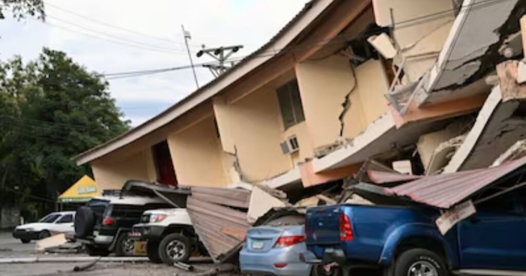
The October 9, 2026, Panama earthquake prompted reports of damage to buildings, roads, and public infrastructure in several affected areas. Emergency teams and relevant authorities began assessing conditions to identify safety risks and determine whether damaged structures required further inspection. The full impact of a major earthquake can take time to establish because some structural damage is not immediately visible.
Reports published as the situation developed described injuries associated with the earthquake, including incidents involving falling debris. Early casualty figures may differ between news reports because information is collected and verified at different times. For accurate information about deaths, injuries, and damaged properties, readers should consult the latest statements from Panama’s emergency authorities and reliable news organizations instead of relying on initial estimates.
Earthquakes can also disrupt daily life even in areas where widespread structural collapse does not occur. Residents may face transportation delays, temporary power interruptions, building evacuations, and difficulties accessing essential services. Aftershocks can create additional risks for already weakened structures. People in affected communities should follow official safety instructions, report serious hazards to the appropriate authorities, and avoid entering damaged buildings until they have been assessed and declared safe.
Did the Panama Earthquake Affect the Panama Canal or Airport?

The Panama Canal is a major international shipping route connecting the Atlantic and Pacific oceans. Following the October 9, 2026, earthquake, initial reports indicated that canal operations continued while technical teams assessed facilities and considered worker and vessel safety. For the latest information about canal operations, restrictions, or service disruptions, check announcements from the Panama Canal Authority.
Tocumen International Airport in Panama City was also affected by the immediate response to the earthquake. Initial reports described a temporary suspension of operations, followed by a resumption of flights. However, an earlier reopening announcement does not guarantee that every flight is operating normally now. Travelers should check the official Tocumen International Airport website and confirm flight details directly with their airlines.
Earthquakes can prompt precautionary inspections of airports, ports, roads, bridges, and other critical infrastructure. Even when a facility remains operational, inspections may continue to identify possible damage and protect workers and travelers. Anyone planning to travel through Panama should rely on current official announcements rather than assuming that conditions remain unchanged since the initial earthquake reports.
Why Does Panama Experience Earthquakes?
Panama experiences earthquakes because it lies in a tectonically active region where the Caribbean, Cocos, Nazca, and South American plates interact. Their movements create stress in the Earth’s crust, which can cause rocks to slip along faults and release energy as seismic waves.
Panama is also located near the Pacific Ring of Fire, a region known for frequent seismic activity. However, earthquake risk varies across the country depending on local faults, soil conditions, and building quality.
The Azuero-Soná Fault System was identified in early reports as a possible source of the October 9, 2026, earthquake. Scientists need seismic data and geological evidence to confirm an earthquake’s source. Although they can assess earthquake hazards, they cannot predict the exact time and magnitude of the next earthquake.
Which Areas of Panama Are at Earthquake Risk?
Earthquake risk is not limited to one city or province. Historical seismic records and geological research identify active faults and earthquake-prone regions across Panama, including areas near the Costa Rican border, the Pacific coast, and parts of central Panama. The western provinces and offshore regions also have significant tectonic activity.
The October 2026 event highlights the importance of preparedness in central provinces that may not experience a major earthquake every year. A location can experience strong shaking even if it is not directly on the epicenter. Local soil, the depth of the earthquake, the distance from the fault, and construction quality all influence the effects.
| Area | Earthquake-related concern |
| Herrera | Close to the reported October 2026 epicenter |
| Los Santos | Reported structural damage and road concerns |
| Veraguas | Reports of roadway fissures and earthquake impacts |
| Coclé | Damage reported in Penonomé |
| Panama City | Strong shaking, precautionary evacuations, and building inspections |
| Chiriquí and the Costa Rican border | Known regional seismic activity |
| Panama Canal area | Active faults have been studied for their potential hazard to infrastructure |
These are general risk considerations, not a prediction of future damage. Local emergency agencies and geological hazard maps provide more specific information for individual communities and properties.
How to Check Live Panama Earthquake Updates
When people search for “Panama earthquakes,” they may want to know whether a new earthquake has occurred, how strong it was, or whether another tremor could affect their location. The safest approach is to consult official seismic monitoring services and compare their reports with statements from local emergency authorities.
The USGS provides earthquake maps, magnitude estimates, depth information, epicenter locations, and reports from people who felt shaking. Panama’s local geoscience and civil protection authorities can provide information about evacuations, damaged areas, road closures, and other public safety measures. News agencies can help explain developments, but breaking reports may change as more information becomes available.
Useful sources include:
- USGS Latest Earthquakes for live seismic information and event details.
- USGS Panama earthquake event page for the October 9 magnitude 7.7 earthquake.
- Associated Press Panama earthquake coverage for reported damage, evacuations, and developments.
- Reuters earthquake report for infrastructure and impact updates.
When checking a live earthquake map, pay attention to the event time, magnitude, depth, and location. Also check whether a displayed event is a new earthquake or an aftershock. Two reports may describe the same event while showing different magnitudes because scientists revised the initial estimate.
What to Do During an Earthquake in Panama
Earthquake safety begins with knowing how to protect yourself before the shaking stops. If you are indoors, the recommended response is to drop to your hands and knees, cover your head and neck, and take shelter under a sturdy table or desk if possible. Hold on until the shaking ends. Stay away from windows, glass, tall furniture, and objects that could fall.
If you are outdoors, move away from buildings, streetlights, trees, power lines, and other objects that could collapse or fall. If you are driving, pull over safely away from bridges, overpasses, and power lines, then remain inside the vehicle until the shaking stops. Do not rush toward an exit while objects are falling around you.
Follow these practical earthquake safety steps:
- Drop, cover, and hold on: Protect your head and neck during shaking.
- Avoid elevators: Use stairs only when the shaking has stopped and evacuation is safe.
- Expect aftershocks: Be prepared to protect yourself again.
- Keep emergency supplies ready: Store drinking water, food, a flashlight, a first-aid kit, and essential medicines.
- Check for hazards: Look for damaged walls, broken glass, exposed wiring, and gas leaks without putting yourself at risk.
- Follow official instructions: Use local emergency alerts for evacuation guidance and shelter information.
The most important rule is to avoid re-entering a damaged building until qualified authorities say it is safe. A building that appears stable from the outside may have hidden structural damage. If you smell gas, notice a damaged electrical system, or see serious cracks, move to a safe location and contact the appropriate emergency service.
Are Aftershocks Expected After the Panama Earthquake?
Aftershocks are smaller earthquakes that occur after a larger earthquake in the same general region. They happen as the surrounding rocks adjust to changes in stress caused by the main event. Some aftershocks are too weak to notice, while others can produce strong shaking and cause additional damage.
The October 9 earthquake was followed by dozens of reported aftershocks, including several moderate tremors. This activity made continued caution important for residents in affected provinces. People should avoid damaged buildings and follow local instructions even if they feel that the strongest shaking has already passed.
Scientists can estimate the likelihood of additional aftershocks using seismic data, but they cannot reliably predict the exact time, location, and magnitude of every future earthquake. It is therefore misleading to claim that a particular aftershock will definitely happen at a specific hour. Check official earthquake updates instead of relying on unverified social media predictions.
Was There a Tsunami Warning After the Panama Earthquake?
A tsunami warning was issued after the October 9 earthquakes because powerful offshore or coastal earthquakes can sometimes displace seawater and generate dangerous waves. The initial warning covered parts of the Pacific coast, including areas of Panama and neighboring countries. Authorities later lifted the warning, according to the Associated Press.
A lifted warning means that the relevant authorities no longer consider the earlier alert necessary under the conditions assessed at that time. It does not mean that people should ignore all coastal hazards or disregard a new warning. Tsunami risk depends on the earthquake’s location, depth, fault movement, and whether the seafloor was displaced.
People near the coast should follow official tsunami alerts and evacuation instructions. If a strong or prolonged earthquake occurs near the sea, move inland or to higher ground when instructed, and do not return to the shoreline until authorities confirm it is safe. Never go to the beach to watch unusual waves.
Major Historical Earthquakes in Panama
Panama has experienced significant earthquakes throughout its history. The region’s active faults and tectonic boundaries have produced both damaging local earthquakes and events near neighboring countries that affected communities across the border. Historical records help scientists understand the possible size and effects of future earthquakes.
One important historical event occurred on May 2, 1621, when an earthquake associated with the Pedro Miguel fault partially destroyed Panama Viejo, the former site of Panama City. Research published through the USGS describes evidence of significant movement along the Pedro Miguel and Limón faults. These faults are also relevant to seismic hazard assessments around Panama City and the Panama Canal.
Another major regional event occurred in 1991. A magnitude 7.4 earthquake centered in nearby Costa Rica caused deaths, injuries, and extensive damage in the Bocas del Toro border region. This event demonstrates that earthquakes outside Panama’s borders can still create serious local impacts.
The 2026 earthquake adds another important event to the country’s seismic history. Researchers will need to examine recordings, fault movements, and damage surveys to understand the event more completely. Historical comparisons are useful for risk planning, but an earlier earthquake does not establish exactly when the next one will occur.
How Can Residents and Travelers Prepare for Future Earthquakes?
Preparation can reduce injuries and make recovery easier after an earthquake. Residents should identify safe places in their homes, secure heavy furniture, keep emergency supplies accessible, and make a family communication plan. People living in earthquake-prone regions should also know how to turn off utilities safely when necessary and understand the evacuation routes in their communities.
Travelers should learn the emergency procedures at their hotels, keep essential documents and medication accessible, and monitor local announcements during periods of increased seismic activity. Anyone planning to visit Panama should check official travel and transport updates rather than canceling or continuing a trip based solely on social media posts.
Businesses and property owners can improve readiness by inspecting buildings, securing shelves and equipment, maintaining emergency lighting, and training employees in evacuation procedures. Older structures and buildings with visible damage may require professional engineering assessments. Strong building standards can reduce risk, but no building should be assumed completely earthquake-proof.
Frequently Asked Questions
How strong was the Panama earthquake on October 9, 2026?
The USGS reported a magnitude 7.7 earthquake near Pitaloza Arriba in Herrera Province. It occurred at a reported depth of 12.6 kilometers.
Where did the Panama earthquake happen?
The main earthquake’s epicenter was near Pitaloza Arriba in central Panama. Reports described impacts in Herrera, Los Santos, Veraguas, and other areas.
Is Panama still experiencing aftershocks?
More than 45 aftershocks were reported after the main earthquake in the initial coverage. Current activity can change, so check the USGS live earthquake map for the latest recorded events.
Was the Panama Canal damaged?
Initial reports said that the Panama Canal continued operating normally while technical teams inspected facilities. Check the Panama Canal Authority for subsequent operational updates.
Is Panama at risk of future earthquakes?
Yes. Panama lies in a tectonically active region where several plates and fault systems interact. The timing and magnitude of individual future earthquakes cannot be predicted precisely.
Conclusion
The October 9, 2026, Panama earthquakes brought renewed attention to the country’s seismic risks, with a magnitude 7.7 main shock, a second major tremor, and numerous aftershocks reported. Damage to buildings, road disruptions, evacuations, and a temporary airport suspension showed why earthquake preparedness remains essential. Initial reports indicated that the Panama Canal continued operating normally, while assessments of the earthquake’s full impact continued.
Anyone following Panama earthquakes should rely on official seismic records and local emergency announcements for accurate updates. Residents and visitors can reduce their risks by preparing emergency supplies, learning earthquake safety procedures, and staying away from damaged structures. Although scientists cannot predict the exact timing of the next earthquake, reliable information and practical preparation can help people respond more safely.
